

Fall began September 23 with the arrival of the Autumnal Equinox. Most lower elevations have yet to see a freeze event and thus far there has been little, if any, snowfall.
This item is available in full to subscribers.
To continue reading, you will need to either log in to your subscriber account, or purchase a new subscription.
If you are a current print subscriber, you can set up a free website account and connect your subscription to it by clicking here.
If you are a digital subscriber with an active, online-only subscription then you already have an account here. Just reset your password if you've not yet logged in to your account on this new site.
Otherwise, click here to view your options for subscribing.
Please log in to continue |
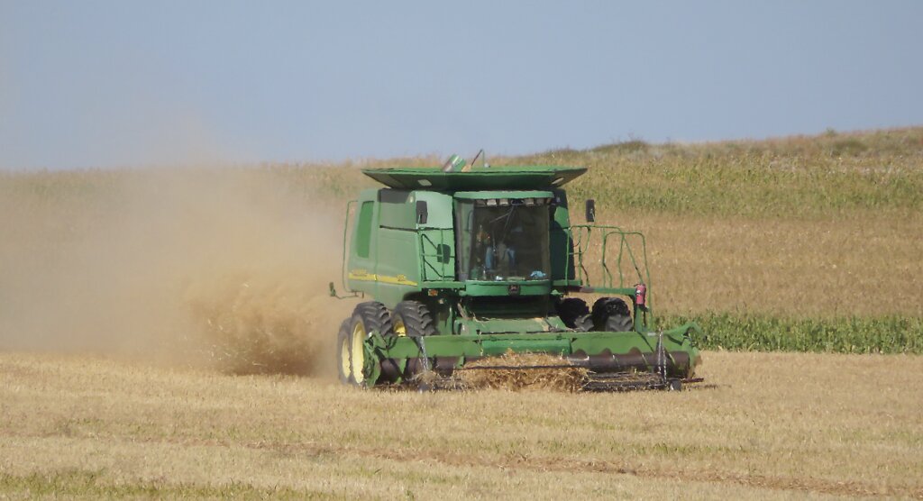
KIMBALL – Generally warm, dry, and sunny conditions continued to push crop maturation across the region and allowed for a significant increase in harvest operations. Overnight temperatures fell into the 30s below 5,000 feet, while freezing overnight temperatures were fairly common at higher elevations. Scattered precipitation events delivered light to moderate rainfall in a few localized areas.
Well managed pastures and rangeland continued to look quite good. Where light to moderate precipitation fell there was an immediate greenup as both warm and cool season grasses took on a healthy tinge of green.
Fall began September 23 with the arrival of the Autumnal Equinox. Most lower elevations have yet to see a freeze event and thus far there has been little, if any, snowfall.
The nearterm regional forecast predicts slightly cooler conditions next week with a slightly elevated chance for precipitation.
Regional Forecast and Conditions
As of Tuesday morning (September 26), the temperature at sunrise was 37 degrees under clear skies. Winds were southwest at 3 mph and the barometer was steady at 30.25 inches of mercury.
The September 26 NWS forecast for today’s weather (Friday, September 29) anticipates sunny skies with a high of about 83. Tonight will be mostly clear with a low of about 46. Day length will be 11 hours and 53 minutes, night length 12 hours and 7 minutes.
Saturday will be sunny and breezy with a high of about 84. Saturday night will be partly cloudy and breezy with a low of about 50 with a slight chance of showers before midnight.
Sunday will be sunny and breezy with a high of about 80 and a slight chance of showers. Sunday night will be mostly clear and breezy with a low of about 48 and a slight chance of showers.
Monday is expected to be mostly sunny and breezy with a high of about 77. Monday night should be mostly clear with a low of about 45. Due to the dynamic nature of weather, forecasts beyond 48-72 hours are inexact.
At Kimball, the September 19-25 daytime high averaged 77 degrees for the third consecutive week. The weekly high temperature was 82 degrees on September 19-20 and 25. Overnight lows averaged 44 degrees, about 0.14 degrees cooler than last week. The weekly low temperature was 36 degrees on September 23. The weekly mean temperature at Kimball was 60.6 degrees, about 0.13 degrees warmer than last week and 0.1 degrees cooler than the September average of 60.7. The 130-year month-to-date (September 1-29) average daily temperature is 60.1. The highest September 1-29 daily average was 70.5 degrees in 1914, with the lowest 52.5 in 1965. The 130-year average high and low temperatures at Kimball for September are 77 and 44.4, respectively.
Total liquid precipitation at Kimball over the September 19-25 period was 0.25 inches from showers on September 20-22.
Winds near Kimball averaged southwesterly and somewhat breezy over the September 19-25 period. Gusts for the week averaged 26.0 mph. High gust for the week was 40 mph on September 23.
Historic climate data
Here’s an overview of September 29 temperature and precipitation highs, lows, and averages over the preceding 130 years at Kimball. Data is taken from the High Plains Regional Climate Center (1893-2016, www.hprcc.unl.edu), and precision weather monitoring on the EJE Ranch south of Kimball (2008-present).
Last year (September 29, 2022): Daily high temperature 83 degrees, overnight low 44 degrees, average temperature 63.5 degrees. Precipitation 0.08 inches, snowfall zero inches, snow depth zero inches.
The warmest September 29 on record was 93 degrees in 1994. The coolest September 29 high temperature was 28 degrees in 1985. The coldest September 29 overnight low was 21 degrees in 1985. The warmest September 29 overnight low was 52 degrees in 1953. Over the years since 1893 the high temperature on September 29 has averaged 71.0 degrees, the overnight low 38.0 degrees, the daily average 54.0 degrees, precipitation has averaged 0.05 inches, snowfall zero inches, snow depth zero inches.
The highest September 29 precipitation total was 1.13 inches (rain) in 1973. Highest snowfall was 3.5 in 1985, highest snow depth 3.1 inches in 1985.
USDA Weekly Crop Reports, September 25
Nebraska – For the week ending September 24, 2023, there were 5.4 days suitable for fieldwork. Topsoil moisture supplies rated 21% very short, 29% short, 48% adequate, and 2% surplus. Subsoil moisture supplies rated 29% very short, 35% short, 34% adequate, and 2% surplus.
Corn condition rated 12% very poor, 17% poor, 22% fair, 38% good, and 11% excellent. Corn mature was 70%, near 68% last year, and ahead of 64% for the five-year average. Harvested was 15%, near 12% last year, and ahead of 10% average.
Soybean condition rated 13% very poor, 17% poor, 25% fair, 36% good, and 9% excellent. Soybeans dropping leaves was 86%, ahead of 79% both last year and average. Harvested was 14%, near 12% last year and 13% average.
Winter wheat planted was 60%, well ahead of 37% last year, and ahead of 51% average. Emerged was 15%, ahead of 4% last year and 9% average.
Sorghum condition rated 4% very poor, 7% poor, 26% fair, 35% good and 28% excellent. Sorghum mature was 45%, ahead of 40% last year, but near 47% average. Harvested was 6%, equal to both last year and average.
Dry edible bean condition rated 2% very poor, 6% poor, 25% fair, 54% good and 13% excellent. Dry edible beans dropping leaves was 69%, behind 81% last year. Harvested was 37%, behind 42% last year.
Pasture and range conditions rated 8% very poor, 15% poor, 37% fair, 29% good and 11% excellent.
Wyoming – A combination of varying temperatures and suitable rainfall, along with 6.2 days suitable for field work allowed for steady harvesting progress across Wyoming during the week. Temperatures across the State were varied, with the eastern part of the State recording temperatures as much as six degrees above average. Many western counties saw temperatures near-average. Rainfall was scattered and total accumulations varied, ranging from a trace to as much as four inches during the week. Some areas received no measurable rainfall. According to the U.S. Drought Monitor for September 19, Wyoming remained drought-free.
Reports from Goshen County indicated winter wheat had emerged and looked good due to adequate moisture levels, while the harvesting of corn for silage has commenced.
Stock water supplies across Wyoming were rated 5% short and 95% adequate, compared with 1% very short, 12% short, 86% adequate, and 1% excellent last week. Irrigation water supplies were rated 1% fair and 99% good, compared with last week’s 10% fair and 90% good.
Colorado – Harvest activities progressed amid mostly warm and dry conditions last week. Isolated precipitation of up to an inch was mostly confined to northern and western counties in the State. Southwestern counties received upwards of an inch of moisture at higher elevations. Northern Weld and Sedgwick Counties received an inch of moisture in areas. Counties in the central and southern portion of the State received over half an inch in some areas. Cooler than average temperatures were widespread across western counties last week, with some areas experiencing daytime high temperatures four degrees cooler than average. Eastern counties experienced maximum temperatures more than eight degrees above average. The U.S. Drought Monitor reported drought conditions remained prevalent in western and southwestern counties. Just over 13% of the State was experiencing dry conditions, and 13% of the State was rated in moderate drought. Three percent of the state was rated in severe drought, equal to last week.
Third cutting of alfalfa progressed with 80% harvested, behind last year and the five-year average at 85%. Fourth cutting remained significantly behind average, with 11% harvested, compared with a five-year average of 30%.
The corn crop continued to mature, with 82% of the crop dented, behind the five-year average of 89%, and 29% of the crop in the mature stage, behind the five-year average of 41%. Corn harvested for silage made good progress last week, with 73% of the crop harvested.
Sugarbeet harvest also began in northeastern counties, with 7% of the crop harvested.
Potato harvest increased its pace in the San Luis Valley last week, with 37% of the acreage harvested.
Stored feed supplies were rated 1% very short, 6% short, 88% adequate and 5% surplus. Cattle death loss was 1% heavy, 61% average and 38% light. Sheep death loss was 3% heavy, 88% average and 9% light.
USDA Weekly Weather Bulletin, September 26
A slow-moving storm system resulted in heavy showers and locally severe thunderstorms in the nation’s midsection, especially across the northern Plains and upper Midwest. A secondary area of heavy rain was focused across the southeastern Plains and neighboring areas. Despite causing temporary fieldwork delays and pockets of flash flooding, the rain largely benefited recently sown and soon-to-be-planted winter wheat.
Wet weather (rainfall locally totaling 1-2 inches or more) lingered in New England, shortly after the remnants of Hurricane Lee soaked eastern Maine. Just before daybreak on Saturday, September 23, northbound Tropical Storm Ophelia made landfall near Emerald Isle, NC, packing sustained winds near 70 mph. Less than 18 hours after moving ashore, Ophelia had lost most of its tropical characteristics and was reclassified as a post-tropical cyclone. Still, the short-lived tropical cyclone, which was first named on Friday afternoon, produced as much as 4-8 inches of rain in the middle Atlantic coastal plain, as well as widespread wind gusts from 50 to 70 mph, with potential implications for open boll cotton in Virginia and North Carolina.
Warmth preceded and accompanied the increasing shower activity, with weekly temperatures broadly averaging 5-10 degrees above average from Texas and southeastern New Mexico to the northern Plains and upper Midwest. In contrast, readings averaged at least five degrees below average in many locations across the central and southern Appalachians, as well as the middle and southern Atlantic States. Separately, temperatures averaged as much as five degrees below average from parts of California to the interior Northwest. Freezes were observed in traditionally colder locations across the Rockies, northern Great Basin, and Intermountain West.
U.S. Drought Monitor
USDM reports derive averages from only the most recent 30 year period. Temperature and precipitation predictions derive from National Weather Service (NWS) and National Oceanic and Atmospheric Administration (NOAA) forecasts.
Current drought status for the Nebraska Panhandle, Southwest Wyoming, and Northeast Colorado. Drought Categories: D0 – average dryness. D1 – moderate drought. D2 – severe drought. D3 – extreme drought. D4 – exceptional drought.
(September 19, 2023) Several Pacific weather systems moved through the jet-stream flow during the week of September 13-19. The upper-level circulation consisted of a ridge over the western U.S., but it was weakened by the traversing Pacific weather systems. The ridge kept most of the western U.S. dry with warmer-than-average temperatures from northern California to Montana. Cold fronts and surface low-pressure systems, that accompanied the weather systems, brought rain to the Southwest, southern Plains, Southeast, and Northeast. Heavy rain fell across western to central Texas, improving drought conditions. The rain in the East fell mostly on non-drought areas. The fronts kept temperatures cooler than average from the Southwest to most of the southern Plains and across much of the country from the Mississippi River to the East Coast – only the Gulf of Mexico coast and New England had a warmer-than-average week. In addition to getting rain from frontal systems, parts of New England were soaked by the remnants of Hurricane Lee over the weekend. The northern Plains and parts of the central Plains, the Great Lakes, and the Mississippi and Ohio Valleys had a drier-than-average week.
High Plains: Half an inch to locally 2 inches of rain fell over western and southern parts of the High Plains region, mostly in Colorado, southern Kansas, and parts of Nebraska. Most of Wyoming, the Dakotas, Nebraska, and Kansas were dry this week. The rain trimmed D0 in southern Colorado and contracted D0-D1 in southwestern Kansas. D0 and D3 expanded in eastern Kansas. D0 expanded in parts of southwest Nebraska, but there was an expansion of D3 and D4 in parts of southeast Nebraska.
West: Half an inch to locally two-plus inches of rain fell over parts of Arizona, New Mexico, and Utah, but most of the West received no rain this week. High evapotranspiration due to summer temperatures, low streamflow and soil moisture, and lack of precipitation over one-month to 12-month time scales resulted in the expansion of D2 and D3 in northwest Washington, expansion of D2 in eastern Washington and the Idaho panhandle, and expansion of D1 and D2 and the introduction of D3 in western Oregon. Rain from weather systems in past weeks, especially the remnants of Hurricane Hilary, resulted in contraction of D1 in central Oregon, D0 and D1 in Utah, and D0 to D3 in western Montana. While parts of New Mexico received rain this week, other parts were dry. The weather system that dumped rain on Texas also soaked east-central New Mexico, so drought contracted there. Dryness resulted in expansion of D1 and D2 in central to northeast New Mexico and D3 in northwest and southern parts of the state, as well as D3 expansion in adjacent southeast Arizona.
Near-term forecast: Looking ahead through September 30, the NWS Climate Prediction Center (CPC) favors above-average precipitation from northern California to North Dakota and across much of the Southeast, with below-average precipitation centered over Colorado and extending from Missouri to the Great Lakes and New England. Odds favor near average precipitation for Alaska. The outlook is for below-average temperatures over southwest Alaska and the Far West in the CONUS, and above-average temperatures from the Rockies to Appalachians and over northeast Alaska.
The temperature pattern favored through October 4 predicts cooler-than-average temperatures extending to the Rocky Mountains and the warmer-than-average area extending to the East Coast. The area favored for above-average precipitation extends across the Great Plains, while the below-average area extends to the Lower Mississippi Valley.
Terminology: EDDI – Evaporative Demand Drought Index. This is an experimental model for drought prediction, using nationwide data from 1980-present. SPI – Standardized Precipitation Index, correlating present month/year precipitation with 30-plus year historical data. SPEI – Standardized Precipitation Evapotranspiration Index. SWE – Snow Water Equivalent.
For more information on the U.S. Drought Monitor, including an explanation of terminology, visit: http://droughtmonitor.unl.edu


